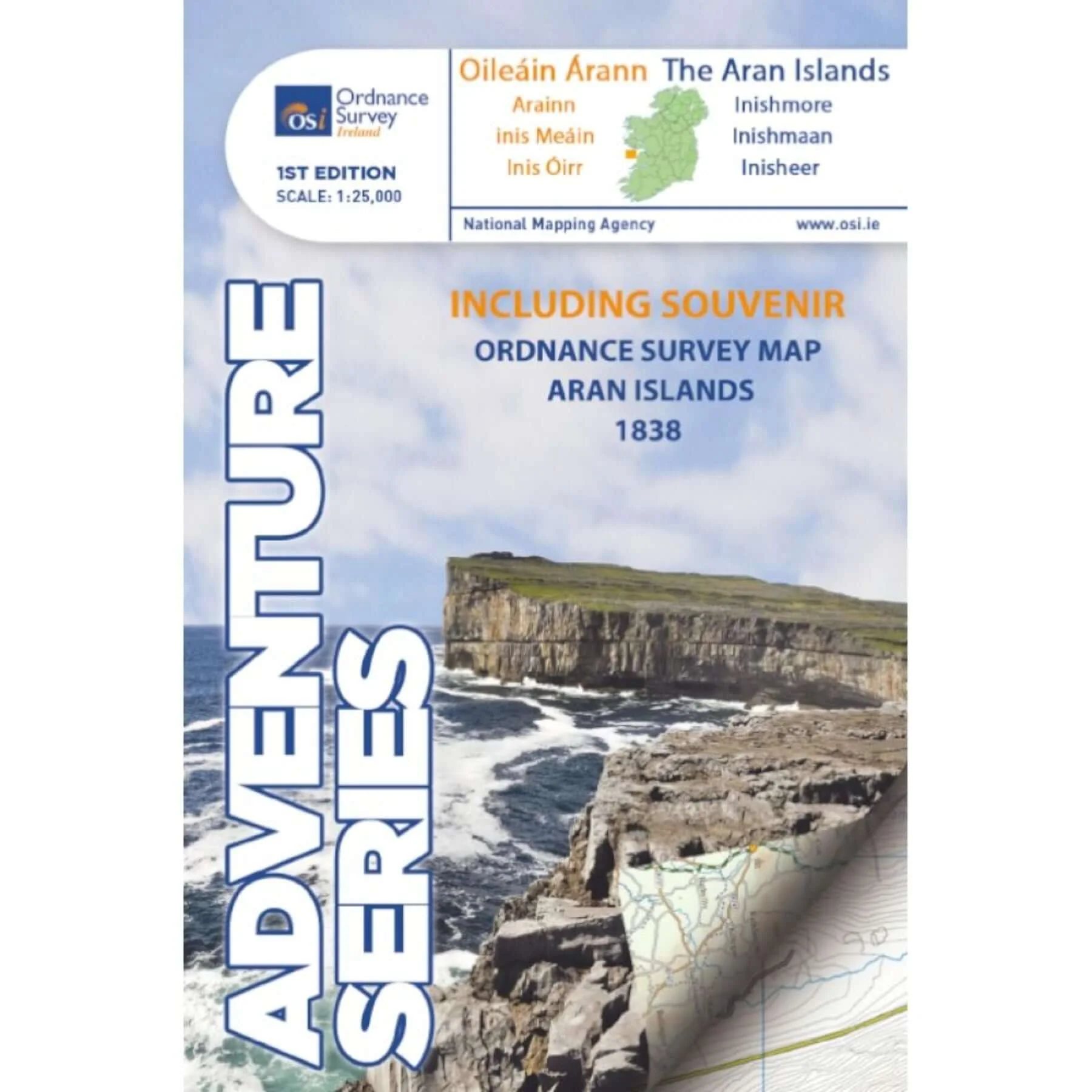
Adventure Series - The Aran Islands
Tá an léarscáil seo lonnaithe i gContae na Gaillimhe. This map is in County Galway.
Léiríonn an léarscáil seo na trí príomh oileáin; Inis Oírr, Inis Meáin, agus an cheann is mó, Árainn. Tá roinnt oileáin beaga ann freisin. Tá roinnt sráidbhailte ar taispáint anseo; Cill Mhurbhigh, Cill Rónáin, agus An Lorgain. Tá seirbhís farantóireachta ann idir na trí oileáin, agus ón mórthír ó Ghaillimh, Dúlainn, agus Ros an Mhíl. Ar an léarscáil seo freisin, tá trí aerstiallacha, ceann ar gach cheann den trí oileáin.
This map shows the three principal islands; Inis Oírr, Inis Meáin, and the largest one, Árainn. A number of small villages are shown here; Cill Mhurbhigh, Cill Rónáin, and An Lorgain. A ferry service operates between the islands, and from the mainland from Galway, Doolin, and Rossaveel. This map displays three airstrips, one on each of the three islands.
Tá sruthanna beaga agus lochanna scaipithe tríd na n-oileáin, an ceann is mó ná An Loch Mór, ar Inis Oírr. Tá cúpla trá beaga ar taobh thuaidh na n-oileáin, agus ar an taobh eile, tá aille áirde ar aghaidh an an tAigéan Atlantach.
There are small streams and lakes scattered around the islands, the biggest being An Loch Mór, on Inis Oírr. There are a few small beaches on the northern coasts, and on the other side there are high cliffs facing the Atlantic Ocean.
Bíonn tarraingt mór ag turasóirí ar na nOileáin Árann, de bharr saibhreas an oidhreacht atá ann, idir an teanga, an stair agus an ceoil tradaisiúnta. Tabharann an léirscáil seo cabhar don cuairteóir chun an dúiche a shiúl, agus an oiread suímh suimiúla, Dún Eochla, Dún Chonchúir, agus an dún aille Dún Aonghusa san áireamh
The Aran islands are a major tourist centre and a cultural treasure, rich in Irish language, history and traditional music. This map helps the visitor to explore the rugged landscape, and visit many interesting sites, including Dún Eochla, Dún Chonchúir, and the cliff fort of Dún Aonghusa.
+
The Adventure Series is an activity oriented map which shows detailed landscape information. It provides detailed mapping in specific locations for the outdoor enthusiast such as mountaineers, hill walkers, cyclists and other users of the Irish countryside. Some of the features included are National Roads, National Secondary Roads, Regional Roads, Waymarked walks, Tracks and Trails, Cycle Routes, Forestry, Land Terrain, Spot Heights, Contours, Named antiquities, Local amenities, National Parks, Lakes, Rivers and Streams. The Series is printed on Water Resistant Paper for greater durability.
Original: $15.31
-65%$15.31
$5.36Product Information
Product Information
Shipping & Returns
Shipping & Returns
Description
Tá an léarscáil seo lonnaithe i gContae na Gaillimhe. This map is in County Galway.
Léiríonn an léarscáil seo na trí príomh oileáin; Inis Oírr, Inis Meáin, agus an cheann is mó, Árainn. Tá roinnt oileáin beaga ann freisin. Tá roinnt sráidbhailte ar taispáint anseo; Cill Mhurbhigh, Cill Rónáin, agus An Lorgain. Tá seirbhís farantóireachta ann idir na trí oileáin, agus ón mórthír ó Ghaillimh, Dúlainn, agus Ros an Mhíl. Ar an léarscáil seo freisin, tá trí aerstiallacha, ceann ar gach cheann den trí oileáin.
This map shows the three principal islands; Inis Oírr, Inis Meáin, and the largest one, Árainn. A number of small villages are shown here; Cill Mhurbhigh, Cill Rónáin, and An Lorgain. A ferry service operates between the islands, and from the mainland from Galway, Doolin, and Rossaveel. This map displays three airstrips, one on each of the three islands.
Tá sruthanna beaga agus lochanna scaipithe tríd na n-oileáin, an ceann is mó ná An Loch Mór, ar Inis Oírr. Tá cúpla trá beaga ar taobh thuaidh na n-oileáin, agus ar an taobh eile, tá aille áirde ar aghaidh an an tAigéan Atlantach.
There are small streams and lakes scattered around the islands, the biggest being An Loch Mór, on Inis Oírr. There are a few small beaches on the northern coasts, and on the other side there are high cliffs facing the Atlantic Ocean.
Bíonn tarraingt mór ag turasóirí ar na nOileáin Árann, de bharr saibhreas an oidhreacht atá ann, idir an teanga, an stair agus an ceoil tradaisiúnta. Tabharann an léirscáil seo cabhar don cuairteóir chun an dúiche a shiúl, agus an oiread suímh suimiúla, Dún Eochla, Dún Chonchúir, agus an dún aille Dún Aonghusa san áireamh
The Aran islands are a major tourist centre and a cultural treasure, rich in Irish language, history and traditional music. This map helps the visitor to explore the rugged landscape, and visit many interesting sites, including Dún Eochla, Dún Chonchúir, and the cliff fort of Dún Aonghusa.
+
The Adventure Series is an activity oriented map which shows detailed landscape information. It provides detailed mapping in specific locations for the outdoor enthusiast such as mountaineers, hill walkers, cyclists and other users of the Irish countryside. Some of the features included are National Roads, National Secondary Roads, Regional Roads, Waymarked walks, Tracks and Trails, Cycle Routes, Forestry, Land Terrain, Spot Heights, Contours, Named antiquities, Local amenities, National Parks, Lakes, Rivers and Streams. The Series is printed on Water Resistant Paper for greater durability.